The Medlar Bridge
A member of the Medlar family told me that there was a bridge over the Grand Canal in the James's St. Harbour area which was known as the Medlar Bridge, the assumption being that it had been named after Councillor PJ Medlar. From my family point of view, linking Councillor Medlar to a bridge over the Canal in the harbour area would be very significant as the Councillor was born on the Upper Ballyellin Lock on the Grand Canal/Barrow River in Co. Carlow.
As the canal "spur" to that harbour (actually the original main line of the Canal) has now been filled in this good while, there are no bridges extant in the harbour area. So I set out on the trail of where it might have been. But, nobody, apparently had heard of the Medlar bridge. There were three bridges there in the old days. Two swing bridges at the harbour itself dating way back and a more modern metal footbridge linking Maryland and Basin St. (formerly Basin Lane, formerly Rape Walk). This last bridge was known as the Cage.
I made enquiries with Dublin City Archivist Mary Clarke who forwarded my request to Peter Walsh who used to run the Guinness museum and archive. Peter came up trumps, disappointingly so in one way, with the information that the Cage had been known as the Mettler (as in metal) bridge by the local youth. It then looked as though I was on a wild goose chase and that the only connection the bridge had with the Medlar family was a phonetic one.
Undaunted, and determined not to let go of a substantive Medlar connection, I trawled the Corporation archives and, lo and behold, Councillor Medlar it was who proposed a motion at the City Council meeting of 6 February 1933 as follows:
That with a view to enabling the City Council to consider the advisability of including the necessary provision in the estimates for 1933/34, the City Manager be requested to obtain from the City Engineer and submit to the Council an estimate of the cost of erecting a foot bridge over the Grand Canal at Mountainview and Upper Basin Sreet. so as to afford through communication from South Circular Road and Dolphin's Barn to James's St. via Maryland.On 24 March 1933, the City Manager in his report to the Council quoted the City Engineer's advice that:
the only feasible arrangement would be to provide for a Bridge opposite the Eastern end of McCarthy Terrace, crossing northward over the Canal and continuing thence by a railed-in passage on the Canal company's ground as far as Brandon Terrace, Upper Basin Lane -- thus affording direct access to James's Street.However, it was not all plain sailing, so to speak. According to the City Manager, in the above report:
The Company, having been approached on the proposal, would only agree to the erection of a bridge over the Canal provided it is fully covered in and that it is brought directly into James's Street Basin instead of along the line mentioned above. These requirements are considered necessary, I understand, to protect the Company's premises from trespass as considerable quantities of oil, etc., are stored on their ground and risk of fire has to be eliminated as far as possible. As the effect of the Company's restrictions would, however, prevent the provision of the suggested facility, and it is possible there may be a way to overcome the Company's anxieties in the matter, I am of the opinion the question should be referred to the Housing and General Purposes Committee to arrange for a conference with the Board of the Canal Company with a view to solving the difficulty. The work, if carried out on the lines contemplated by the City Engineer, would cost approximately £300.The difficulty was overcome and in January 1934 the City Manager could report that:
The lowest tender for the erection of the footbridge at Basin Lane, Grand Canal, viz., that of the City of Dublin Engineering Company at £827.14s. was accepted.As this is more than twice the City Engineer's original estimate, it is likely that the scheme was considerably modified, possibly by more substantial caging covering both the passageway and the bridge itself.
Location
It is difficult to envisage the location of the former bridge today as the scene has changed so much. The canal has been filled in and the delineation of the Canal Company's property is not clear to the passerby. Having checked out such relevant maps as I could get my hands on (thank you, Máire Kennedy) I have estimated the location of the bridge and the cageway into Basin St. The bridge appears on the 1943 and 1970 OS maps of the area. The 1943 map is reproduced on p232 of Ruth McManus's book Dublin 1910-1940: Shaping the City and Suburbs, Four Courts Press, 2002.
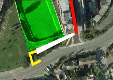
The illustration above takes the Google sattelite image of the area as it is today (2009) and superimposes the locations of the bridge (yellow), the cageway (white), Basin St. (red), and the southern end of the Basin (green). The Company wanted the bridge to go straight across from the southern bank of the Canal and into the Basin area. While it would still cross Company property, this would not be at ground level on the northside of the Canal.
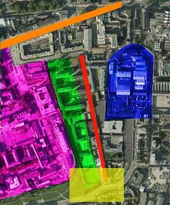
The shot below sets the context. The area of the detail shown above is highlighted in yellow at the botom of the picture. Landmarks are: James's Street (orange), St. James's Hospital (violet), James's Harbour (blue), Basin St. (red) and the old Basin area (green).
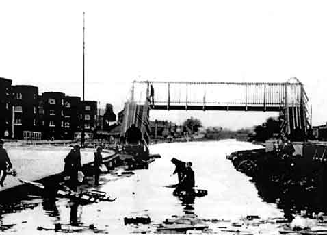
The photo above dates from 1973. It is a slide from Peter Walsh's collection and I thank him for permission to reproduce it here.
You can see quite clearly how the Canal is narrower on the nearside of the bridge than on the far side. This narrow part, leading to the harbour, was known as the Gut.
The extent to which the bridge itself was enclosed is clearly visible.
You can also see Fatima Mansions to the left. This public housing (flats) was built between 1949 and 1951. Originally a positive development it gradually slid down the Corporation's priority list and became a severe problem area. This was due to various cutbacks, rehousing those tenants able to avail of it into purchase houses elsewhere, and the demolition of other flat complexes which had been at the bottom of the pile. Fatima has recently been reconstructed as a mixed public/private development under the name Herberton/Fatima.
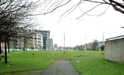
This is a modern (2010) view taken from about the same place as the 1973 photo above. You can see the western corner of the basin on the right, where the bridge would have crossed, and the newly developed Herberton/Fatima on the left. The tarmacadam path in the front approximately represents the path of the canal.
Folklore
The demand for a direct crossing from the south bank of the Canal to Basin St. seems to have arisen after the construction of the estate which subsequently became known as Maryland. This estate, between the Canal and Cork St. came into being in the year of the Eucharistic Congress (1932) at a time of great devotional fervour generally. The Corporation named the six streets as: The Virgin's Road, Our Lady's Road, Annunciation Road, Morning Star Road, Rosary Road and Ave Maria Road. The Virgin's Road and Annunciation Road were subsequently renamed Loreto Road and Lourdes Road.
By the time the bridge was being built the fervour seems to have subsided and it seems to have been referred to in a generic fashion after Basin St., or its base material metal, or the extent to which it was enclosed like a cage.
Beyond the Medlars, a further family connection, testified to by his brother, is that Tony Fleming, a second cousin, fell into the Canal off this bridge. How he managed that is beyond me.
Peter Walsh tells me that young lads used to race each other "across the Mettler".
Another story comes from Lorcan in a comment on bjg's site The Abandoned Mainline of the Grand Canal.
The Iron Bridge was my usual route to school and it was a completely caged in bridge, unlike those over the DART line. The cage continued along the high wall that bounded the Basin to the south. I vaguely remember a huge door/gate in this wall. When the caged in walkway reached the west side of Basin View, there was a cut through to the street. There was a small factory which, based on the contents of their bins, were involved in winding transformers and/or stiching leather straps onto bags/luggage.
[More to come, hopefully.]